
Hiking the top rated hike in NH
Hiking Lincoln and Lafayette the top rated hike in New Hampshire!
Lincoln & Lafayette – Franconia Ridge Adventure
Lincoln & Lafayette mountains. The view of what you’ve hiked as you start to go down.
New Hampshire’s top-rated hike - Lincoln & Lafayette on the Franconia Ridge!
This was our biggest hike of the year, they’re two of New Hampshire’s tallest mountains, the 6th and 7th highest peaks in the state. These were also numbers 6 and 7 for us out of the 48 4,000-footers. We started this 4,000-footer journey about a year ago, saying we’d just “dip our toes in” and see how it went. We weren’t sure if we’d actually work on finishing the list… but here we are, checking them off one by one. Will we complete it? Only time will tell.
Let’s get into this incredible hike… and yes, it really is incredible!

We always take a picture of the trail head start sign, when we begin. Helps to know how long it takes us
Early Start
We started early. Because this hike is super popular. Like, “parking-lot-fills-before-sunrise” popular. We hit the trail around 5:45 a.m. with our headlamps on. Total hiking time: about 8½ hours (not counting breaks). I’m a slow hiker, so we planned for roughly a mile per hour, and for once, our timing was spot on.
Starting in the dark is always a little eerie, especially in northern New Hampshire. There are a few water crossings early on, and as the sun started peeking through the trees, we could see some pretty waterfalls. It’s been a dry year, so nothing too tricky, but the last waterfall (about 1.3 miles in) is the showstopper. That’s also your final water crossing. The rocks there are steep and could be slippery if wet, so I was very thankful for the dry day!


Climbing Toward the Ridge
At about 3 miles, you hit the alpine zone! Almost to your first peak (though not one of the official 48). You’ll reach Little Haystack around 3.2 miles in.
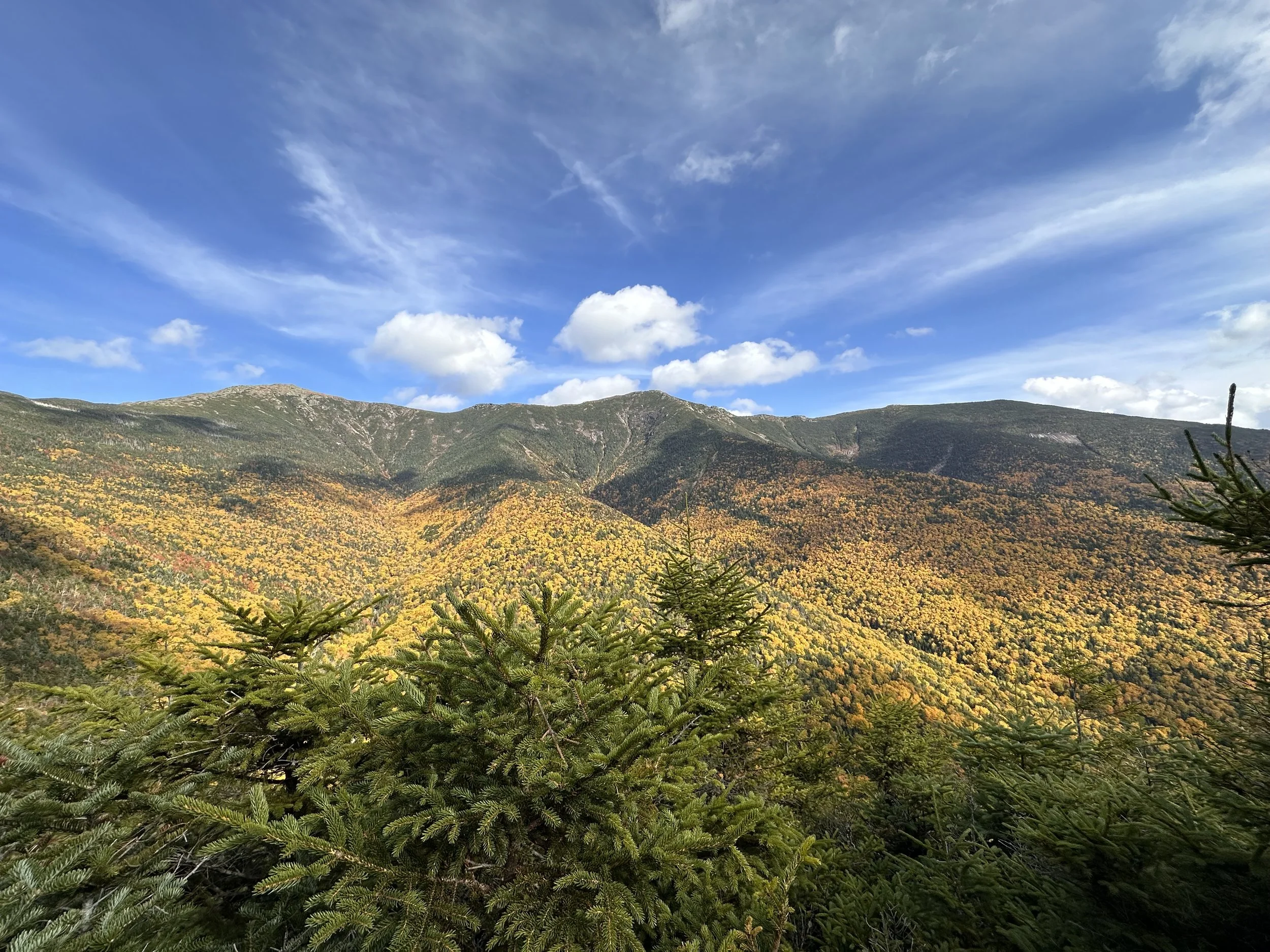
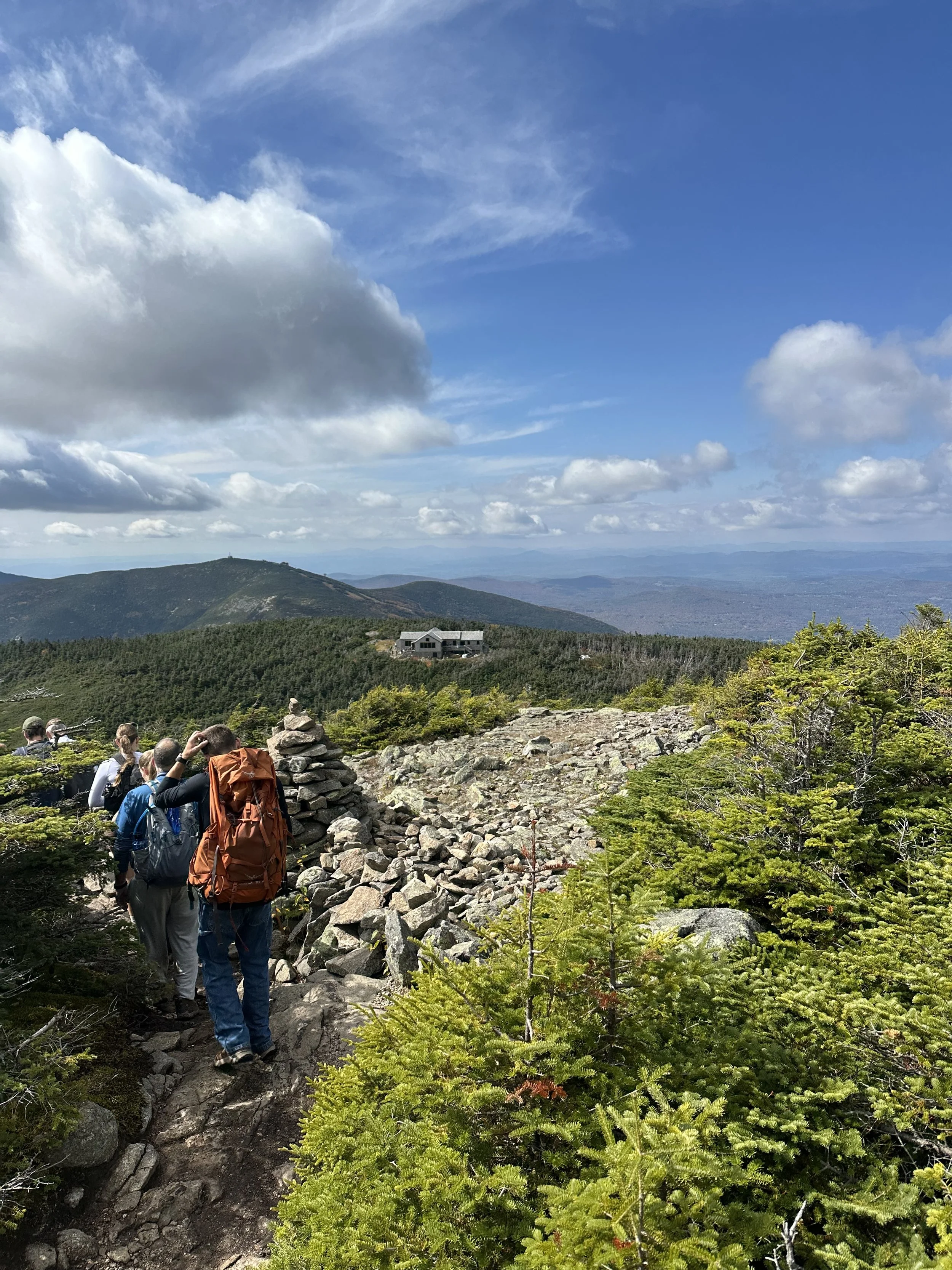
By this point, the faster hikers were catching up, and the trail started getting busier. Don’t forget to look behind you occasionally (one of my hiking tips) Cannon Mountain starts peeking through the trees here. Starting now, the views basically don’t stop for over 2 miles. It’s unreal.
Little Haystack doesn’t count as a 4,000-footer because it lacks 200 feet of prominence. From here, you leave the Falling Waters Trail and join the Franconia Ridge Trail, which is part of the Appalachian Trail, so you might spot a few thru-hikers!
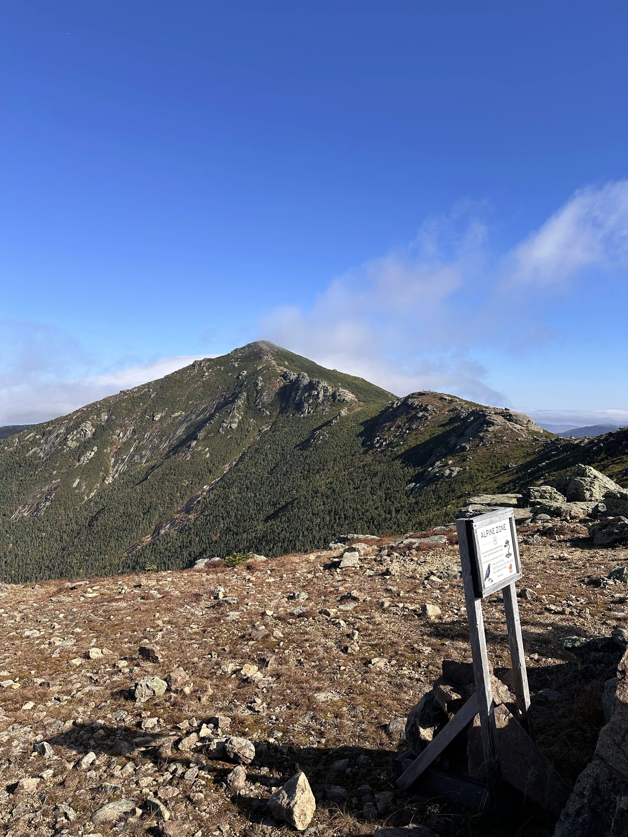
This ridge is where my camera roll exploded. Mt. Lafayette was covered in a moving cloud for a while, and it was pure magic.


Mt. Lincoln
We didn’t linger long at Little Haystack (it was crowded), so we pushed on. The first official 4,000-footer of the day, Mt. Lincoln (5,089 ft), is about 4 miles in, the perfect PB&J break spot.
From here, we could see what looked like the next peak…but surprise! It was a false summit (North Lincoln), another 4,000-footer that doesn’t count. It’s okay though, the ridge is stunning, and sometimes a little scary with those sharp drop-offs toward Cannon. I was very happy for clear weather.


Peak of Mt Lincoln in NH
Mt. Lafayette
The climb to Lafayette gets steep, we even had to use our hands a few times. The summit, at 5,250 ft, comes around 5 miles in. We stopped for another quick snack but didn’t stay long; the crowds were really catching up by now.
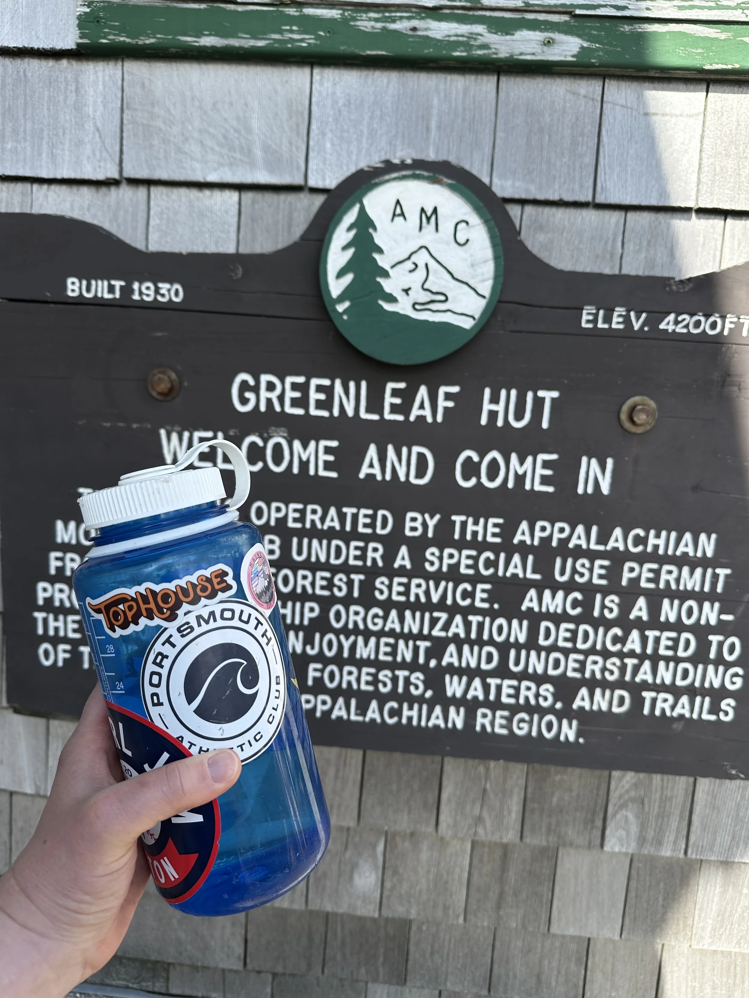
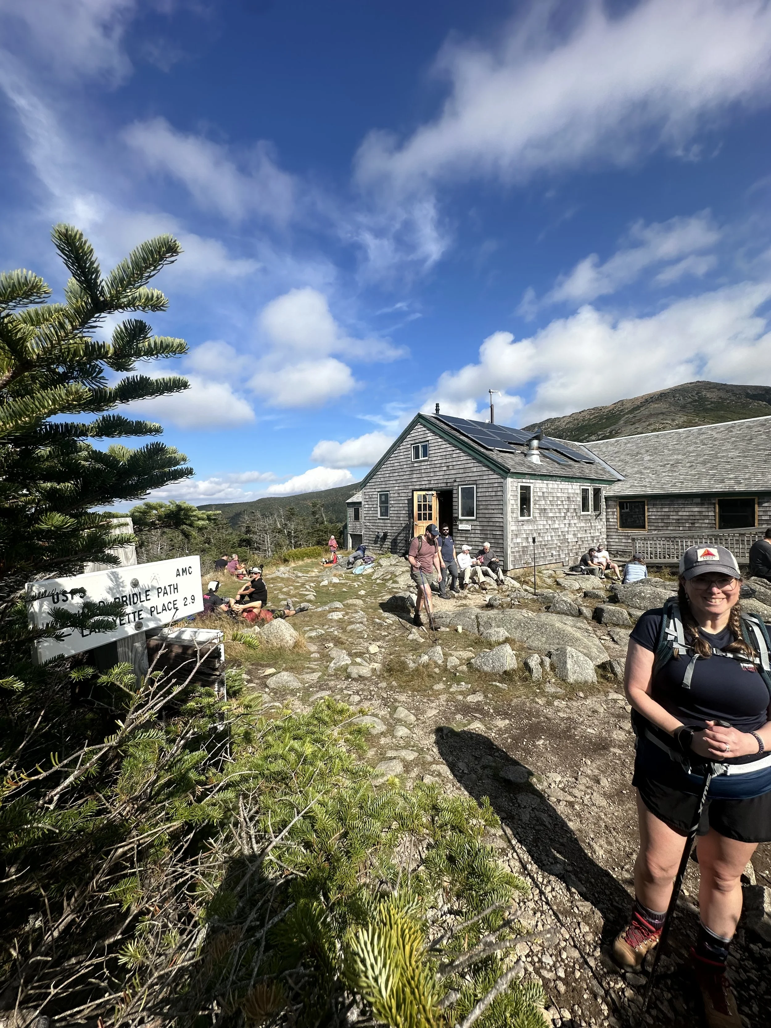
Then came the descent to Greenleaf Hut, about 1.1 miles away, though it looks closer (classic trail illusion). You go down, then up again (of course), before reaching the hut around 6 miles into your day.
This seasonal hut is a gem, a great place for a bathroom break, water refill, or even a snack if they’ve got any left. The day we went, the baked goods were gone (tragic), but they were offering soup and cornbread for a small cash fee. Lesson learned: keep cash in you pack you never know when you can get trail treats!
They also have cold water refills. So refreshing after a hot climb.


The Descent
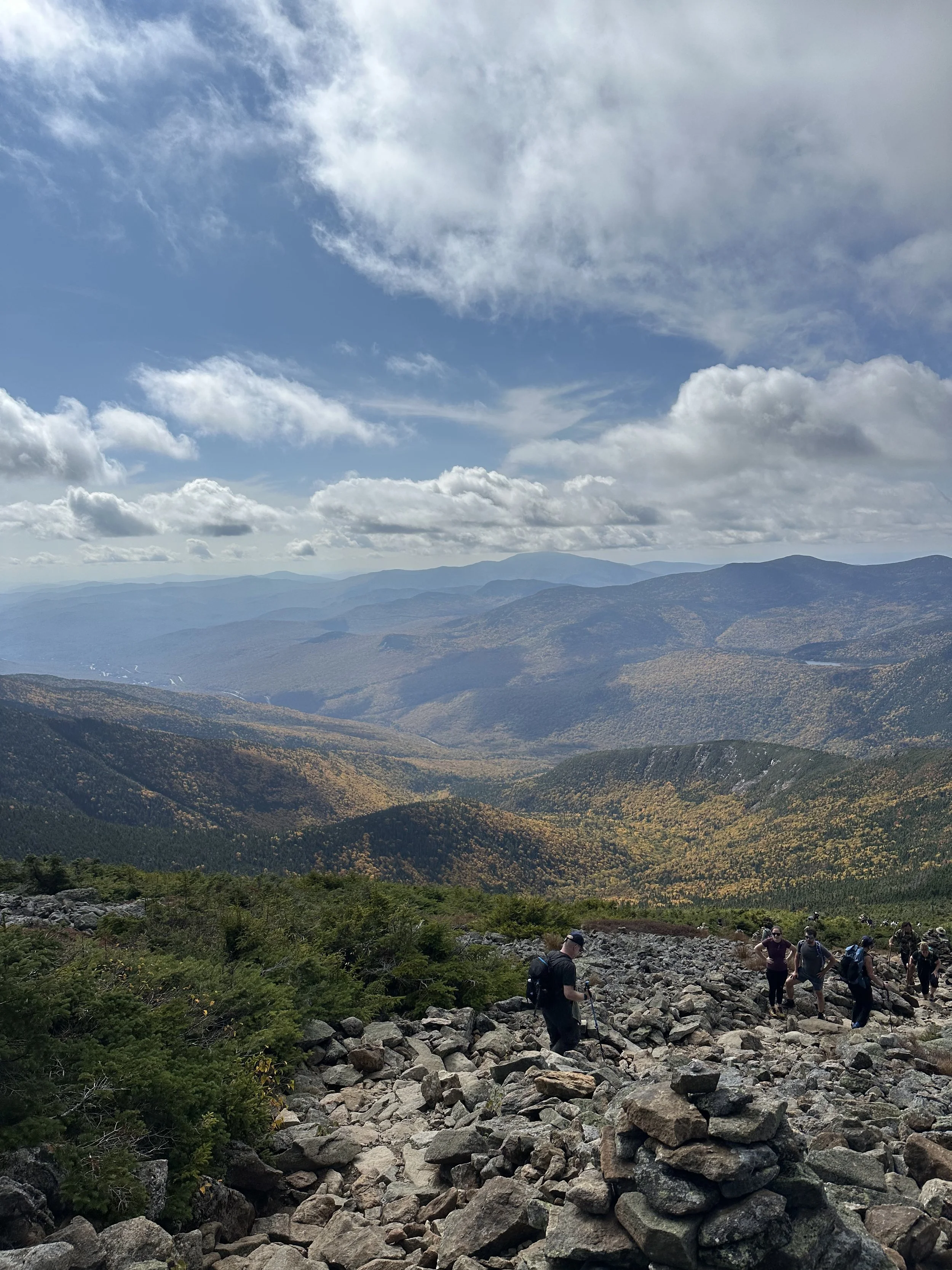
From Greenleaf, make sure you follow the Old Bridle Path down. Go the wrong way, and you’ll have a much longer day than planned. At this point, it felt like a hiker conga line, so I definitely wished we’d gone on a weekday.
You’re still at about 4,200 ft at the hut, which means there’s plenty of downhill left. This stretch follows Agony Ridge (aptly named), with slick, uneven rocks. I had a few “scoot down on my butt” moments here.
Being a slower hiker can be stressful when people are right behind you, especially when there’s no safe spot to step aside. One guy in particular had zero patience, basically flying past everyone. The next day I saw his post in a hiking group bragging about his speed. Let’s just say… I was not impressed.
If any speedy hikers are reading this I will pull over when it’s safe! Promise!


The Final Stretch
Before ducking back into the trees, you get one last stunning view of the ridge you just crossed. That “we just did that” moment? Pretty awesome.
At around 7.3 miles, you’re back in the woods and even though you think you’re almost done, there’s still 1.6 miles to go. The stairs on the descent tricked me into thinking we were close… but nope. Isn’t that always the case?
When we finally reached the parking lot, we saw the hiker shuttle vans that run between Cannon Mountain and the trailhead , a great option if the main lot is full (which it usually is on busy weekends).
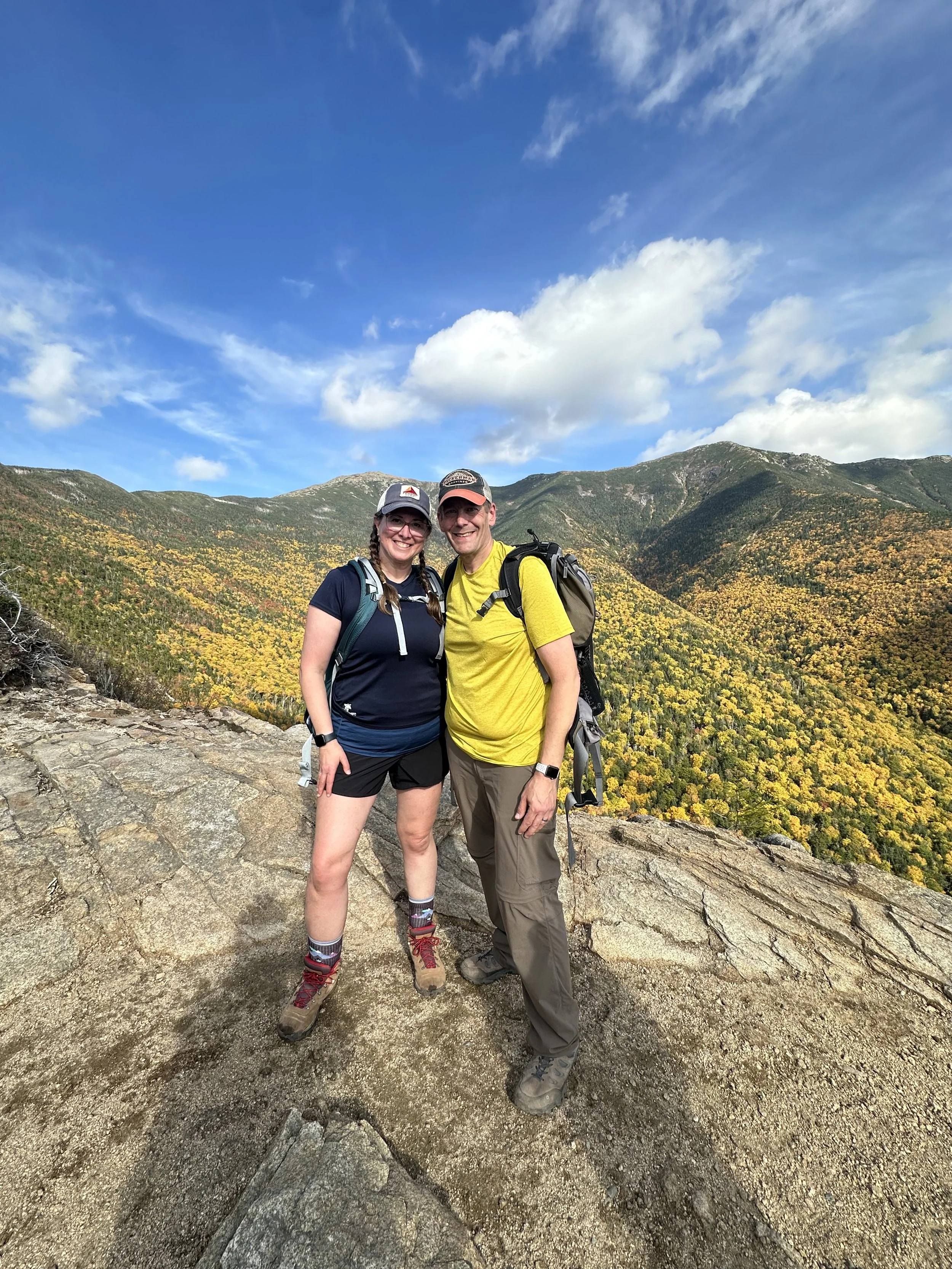
What we just hiked behind us: Lincoln & Lafayette
Final Thoughts
This hike was absolutely amazing and I can’t wait to do it again, hopefully on a weekday next time.
Ratings:
⭐️ Views: 10/10 — jaw-dropping the entire way
💪 Difficulty: 9.5/10 — tough but not soul-crushing
🐶 Dog-friendly: For experienced hiking pups
🚻 Bathrooms: At the trailhead and at Greenleaf Hut
👧 Kid-friendliness: Not a beginner hike, best for experienced hikers or adventurous teens
If you love challenging hikes with unbeatable views, Lincoln & Lafayette deserve a top spot on your list.

New Hampshires 48 4,000-Footers: One Step at a Time
Hiking NH 48 4,000 footers one step at a time
Are we going to hike all 48 of New Hampshire’s 4,000-footers? I don’t know. But we’re going to try our best—one step & one snack break at a time.
This is an ongoing blog I’ll update as we check each NH 4,000-footer off the list. Take our advice or simply learn from our mildly chaotic journey as a couple of enthusiastic, slightly underprepared, outdoors-loving 40-somethings. We’re just trying to trade couch time for trail time—and hey, the views definitely beat doom scrolling the day away!

Mount Osceola peak
Mount Osceola
#1 of 48: You gotta start somewhere!
We only hiked one of the two peaks here—so does it count? Yes. Yes, it absolutely does. Let me explain.
What do I mean by “one of the two”? Well, Osceola has a buddy: East Osceola. They’re often hiked together as a dynamic duo. But since this was our first “big” hike, we decided to ease into it with just one summit. Baby steps, folks. You can read our thought process (and trail logic) in more detail [here]
And yes, we fully realize that if we want to earn that shiny “48” badge, we’ll have to come back and hike it again. But honestly? Worth it. This mountain was a total gem. In my non-expert, mildly sore opinion, it was the perfect introduction to the 4,000-footer club.
We hiked from Tripoli Road on a cool, rainy morning. The trail—though not marked well—was very easy to follow. It’s full of rocks to step over, but there were no scrambles or major climbs. Near the summit, there are some slanted rock slabs to navigate. Trust me when I say it’s best to walk on the awkward spot close to the ground. (You can listen to me explain why on our podcast episode [here].)
The views from the top were absolutely gorgeous. We could see the Waterville Valley ski area among the surrounding mountains.


This was a magical mountain for us to climb, and if you’re looking for a beginner-friendly 4,000-footer, this one should definitely be on your list!
Stats:
Elevation: 4,340 feet
Elevation gain: 2,040 feet
Distance: 6.4 miles round trip
Views: 10/10
Difficulty: 7/10

From the summit of Mount Pierce.
Mount Pierce
#2 of 48: One Step Closer!
We tackled this one toward the end of winter—aka that fun time of year in New Hampshire when it’s sunny in the parking lot but feels like Everest at the summit.
Microspikes were a must from start to finish, but snowshoes? Not even close. The snow on the trail was packed into a narrow monorail path, and stepping off it meant immediate regret (and post-holing up to your kneecaps). At one point, I casually sank my hiking pole all the way to the handle just a few inches off the trail. That was enough science for one day.
Mount Pierce was our first adventure into the Presidential Range, which felt pretty epic for our second 4,000-footer. We started at the AMC Highland Center, which has a big, easy-to-find parking lot. Just cross the street and boom—you’re at the trailhead for the Crawford Path.
This trail comes with serious historical street cred. It was first cut in 1819, making it the oldest continuously used mountain trail in the U.S. The Crawford family created it from their homestead (now Crawford Notch) to the summit of Mount Washington. Imagine deciding to cut a trail to the highest point in the Northeast—just because you could.


The hike starts climbing pretty quickly and doesn’t let up much. About 0.6 miles in, you get to see the very lovely Gibbs Falls, and the trail follows a river for a bit before breaking off. Roughly 0.7 miles from the summit, there’s a trail to the AMC Mizpah Spring Hut, which is closed in winter, so we stayed on Crawford Path. That side trail does loop around to the summit if you’re feeling extra ambitious in warmer months.
As you near the top, the trees start to thin, and suddenly—you’re in the Alpine Zone. There’s even a bench (yes, a bench!) where you can take in stunning views of Bretton Woods, the Mount Washington Hotel, and the looming beauty of Mount Eisenhower and Mount Washington right in front of you.
And then... in classic White Mountain fashion, the weather pulled a fast one. We felt a breeze entering the Alpine Zone, but by the time we reached the true summit just a few hundred feet later, the wind had cranked up and the cold rolled in like it had an appointment. So, instead of a scenic summit lunch, we hightailed it back to the tree line and picnicked there. Slightly less epic—but significantly warmer.
This hike was a blast. It was easier than we expected (thanks, packed trail!), and the views were absolutely top-tier. We’re officially hooked on the Presidential Range and can’t wait to check more off the list.
Stats:
Elevation: 4,310 feet
Elevation gain: 2,400 feet
Distance: 5.9 miles round trip
Views: 10/10
Difficulty: 6/10

Canadian Jay is eyeing our lunch with Mount Washington in the background.
Mount Jackson
#3 of 48: Jays, Ice, and Jaw-Dropping Views
This one had a little bit of everything: icy trails, sweeping views, and feathered trail companions that got very comfortable with us.
The hike starts out across from the Crawford Notch train station. We parked by the lake which is near the trailhead. We were very grateful to have our spikes as the trail was solid ice in places and packed snow in others. Snowshoes weren’t necessary (thankfully), but any step off the main path was instant regret. Classic monorail conditions. We were very glad we had our poles as well!
The trail itself wastes no time. It climbs steadily through the woods and throws in a few steeper sections just to keep things interesting. We didn’t hit anything technical, but the consistent ice made things a little more mentally taxing than usual. Near the top, the trail opens up to some rock slabs—this is the one area where we ditched the spikes for better grip. From there, it’s just a short, breezy push to the summit. And what a summit it is.
We were lucky enough to get a clear day, and the views of the Presidential Range were magical. Similar to Mount Pierce, this vantage point made Mount Washington look massive and snowy in the distance, and the surrounding peaks felt close enough to touch. Definitely one of those “whoa, this is why we hike” moments. As an added bonus, we even remembered to bring and use our binoculars!
The Canadian jays were something else! These bold little guys popped out just before the summit and were more than happy to hang out for a while. They were quite attentive and aggressive when we ate our peanut butter and jelly sandwiches!


If you want to hear us talk more about the trail conditions, our bird encounters, and our exciting ending to the hike, you can listen to the Mount Jackson episode.
All in all, Mount Jackson was a gem. In our completely non-expert, but slightly more confident opinion, this was one of the more rewarding hikes we’ve done so far. If you’re working on the 48, don’t sleep on this one. We’ll gladly come back for a summer version someday—but even with the ice, we’d do it all over again.
Stats:
Elevation: 4,052 feet
Elevation gain: ~2,150 feet
Distance: 5.2 miles round trip
Views: 10/10
Difficulty: 7/10

The Sandwich Range from The Boneyard ski trail at Waterville Valley on Mount Tecumseh
Mount Tecumseh
#4 of 48: Shortest 4,000 footer but a Straight Up Beast (SUB)
If you are looking for a 4,000 footer that won’t destroy your knees or your weekend plans, this hike is for you! The trailhead starts in the parking lot of the Waterville Valley ski area. Although this mountain is still listed as one of the 48 4,000 footers, it technically is a few feet lower than 4,000 feet when measured using more advanced LIDAR (Laser Imaging, Detection and Ranging) technology in 2019. The Mt Tecumseh Trail trailhead starts in the parking lot of the Waterville Valley ski area. There are no bathrooms available but the parking is free from the ski area. There is another trail that starts off Tripoli Road that is longer, and less steep, but we did the steeper Mt Tecumseh Trail.
The trail follows the edge of the ski area most of the way up to the summit. There are two spots on the trail that peek out to the ski trails. Take the moment to walk over and enjoy the views of Waterville Valley from the trail. The views at the true summit of Tecumseh aren’t great. The trees block any 360 degree views. There is an option to go over to the ski area summit via the .5 mile Sosman Trail. We didn’t venture off for that, but it is an option and the views are much better from the ski area. The views include the Osceola and East Osceola, and the Sandwich range.


Just because this mountain is short, doesn’t mean it’s easy, but it is certainly doable! The trail is mostly a steady incline - no huge scrambles or exposed ledges. You’ll gain elevation pretty consistently, there are a few rocky sections, but there are about a million stone stairs! The trail is very well maintained and even though its mostly tree covered, it was very peaceful. This is a good hike for your dogs too!
Mount Tecumseh might be the shortest of the 48, but it was not super easy. It’s a great confidence building hike. Whether you are are just starting your journey, or looking to squeeze in a hike before lunch, this “little” mountain delivers big satisfaction!
Stats:
Elevation: 4,003* feet
Elevation gain: ~2,150 feet
Distance: 5.0 miles round trip
Views: 6/10
Difficulty: 7/10